
Other ITA web sites:

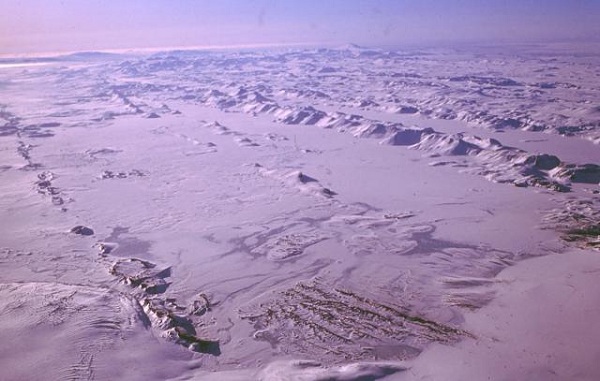
Bardarbunga Volcano, Iceland
The large central volcano of Bardarbunga, seen here from the NW with Grimsvotn volcano in the background, lies beneath the NW Vatnajokull icecap and contains a 700-m-deep caldera.
Related fissure systems, including the lengthy Veidivotn and Trollagigar fissures, have been the source of major Holocene eruptions.
Along with neighboring Grimsvotn, Bardarbunga is one of the most active volcanoes in SE Iceland.
Jokulhlaups (glacier-outburst floods) from eruptions at Bardarbunga potentially affect drainages in all directions.
PHOTO SOURCE: Oddur Sigurdsson, 1977 (Icelandic National Energy Authority), courtesy of the Global Volcanism Program, Smithsonian National Museum of Natural History, used with permission.
The subglacial Loki-Fögrufjöll volcanic system, seen here from the ENE, is located SW of Bárdarbunga volcano and is also part of the Bárdarbunga volcanic system.
It contains two subglacial ridges extending from the largely subglacial Hamarinn central volcano; the Loki ridge trends to the NE and the Fögrufjöll ridge, seen here, extends to the SW.
SOURCE: Photo by Oddur Sigurdsson, 1994 (Icelandic National Energy Authority), courtesy of the Global Volcanism Program, Smithsonian National Museum of Natural History, used with permission.

The Veidivötn fissure system, which extends 100 km SW from Bárdarbunga volcano, has been the source of major eruptions during the Holocene.
A large, dominantly explosive eruption at about 870 AD from the Vatnaöldur crater row, which extends diagonally across the center of the photo, deposited tephra over much of southern Iceland.
The Vatnaöldur eruption originated from a 42-km-long fissure and produced 3.3 cu km of tephra at the time of the settlement of Iceland, forming the the Landnam (Settlement) tephra layer.
SOURCE: Photo by Ingibjörg Kaldal (Icelandic National Energy Authority), courtesy of the Global Volcanism Program, Smithsonian National Museum of Natural History, used with permission.
NOTE: The information regarding Volcano on this page is re-published from other sources. No claims are made regarding the accuracy of Volcano information contained here. All suggestions for corrections of any errors about Volcano photos should be addressed to the copyright owner noted below the photo.