
Other ITA web sites:

Tacana volcano, Mexico and Guatemela
Tacana is a 4060-m-high composite stratovolcano that straddles the Mexico/Guatemala border at the far NW end of the Central American volcanic belt.
The volcano is seen here from the ENE, on the Guatemalan side of the border, where it rises steeply above a 9-km-wide caldera surrounded by deeply dissected plutonic rocks.
Historical activity at Tacana has been restricted to mild phreatic eruptions, but more powerful explosive activity, including the production of pyroclastic flows, has been documented in prehistorical time.
Tacana is a 4060-m-high composite stratovolcano that straddles the Mexico/Guatemala border at the NW end of the Central American volcanic belt.
The volcano rises 1800 m above deeply dissected plutonic and metamorphic terrain.
Three large calderas breached to the south, and the elongated summit region is dominated by a series of lava domes intruded along a NE-SW trend.
Volcanism has migrated to the SW, and a small adventive lava dome is located in the crater of the youngest volcano, San Antonio, on the upper SW flank.
Viscous lava flow complexes are found on the north and south flanks, and lobate lahar deposits fill many valleys.
Radial drainages on the Guatemalan side are deflected by surrounding mountains into the Pacific coastal plain on the SW side of the volcano.
Historical activity at Tacana has been restricted to mild phreatic eruptions, but more powerful explosive activity, including the production of pyroclastic flows, has occurred as recently as about 1950 years ago.
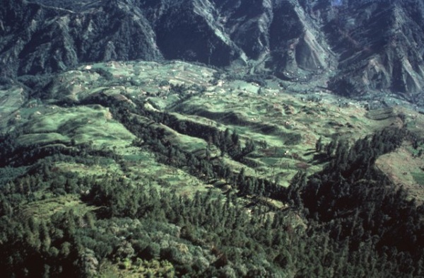
An aerial view of the Rio Las Majadas valley in Guatemala on the NNE side of Tacana volcano shows thick deposits of lahars and debris avalanches filling the valley.
These deposits provide a flat surface for agricultural use in deeply dissected terrain.
The valley drains from its headwaters in Guatemala through Mexico into the Pacific Ocean, and mudflows during future eruptions could affect both countries.

Aerial view of Tacana volcano.

Minor phreatic eruptions took place at Tacana in February, May, and June 1986.
Following a seismic swarm beginning the previous day, a moderate phreatic explosion around noon on May 8 created a new 10-m-wide vent and ejected a small amount of fine ash.
Vegetation was partially destroyed over an area of 200 x 100 m.
Vigorous steam emission was continuing at the time of this June 25 photo.
The new vent was formed at about 3600 m elevation on the NE flank, along the Mexico/Guatemala border.

On the slopes of Tacana

An aerial view of the NE flank of Tacana volcano on June 25, 1986 shows a steam plume rising above a new vent.
Minor phreatic eruptions took place at Tacana in February, May, and June 1986, the first since 1949.
Following a seismic swarm beginning the previous day, a moderate phreatic explosion around noon on May 8 created a new 10-m-wide vent and ejected a small amount of fine ash.
Vegetation was partially destroyed over an area of 200 x 100 m.
The new vent was formed along the Mexico/Guatemala border at about 3600 m elevation.

The summit of Tacana from the air.

Tacana is a 4060-m-high composite stratovolcano that straddles the Mexico/Guatemala border.
The volcano, seen here from the SSE at the Mexican town of Union Juarez, rises above the Pacific coastal plain.
The elongated summit region is dominated by a series of lava domes extruded along a roughly NE trend.
Historical activity has been restricted to mild phreatic eruptions, but more-explosive activity, including the production of pyroclastic flows, has been documented in prehistorical time.

Tacana volcano is located near the NW border of the Caribbean plate.
The volcano lies about 30 km south of the Polochic fault, in the diffuse zone which marks the Caribbean and North American plate boundary.
The summit of Tacana volcano, seen here from the SSE, is elongated as a result of the extrusion of a series of lava domes along a roughly NE-trending line, with the youngest center, San Antonio, being at the SW (left).
In the center is the Tacana itself, while the Chichuj volcano is at the right.

Another view from the slopes of Tacana.

The low peak on the center horizon is San Antonio (or El Aguila), the youngest peak of the Tacana volcanic complex.
A major eruption from San Antonio volcano on the upper SW flank produced a block-and-ash flow that traveled about 14 km to the south and associated lahars about 1950 years ago.
The eruption concluded with the emplacement of lava flows and a lava dome.
Construction at the pre-Hispanic center of Izapa was halted because of temporary abandonment of the city due to lahars.

Tacana seen from the road.
PHOTO SOURCES: Bill Rose, 1986 (Michigan Technological University), Norm Banks, 1987 (U.S. Geological Survey), courtesy of the Smithsonian National Museum of Natural History Global Volcanism Program, used with permission, Bob and Konrad Kossick (summitpost.org), Flickr, Wikimedia Commons.
NOTE: The information regarding Volcano on this page is re-published from other sources. No claims are made regarding the accuracy of Volcano information contained here. All suggestions for corrections of any errors about Volcano photos should be addressed to the copyright owner noted below the photo.