
Other ITA web sites:

Santorini Volcanic Caldera, Greece
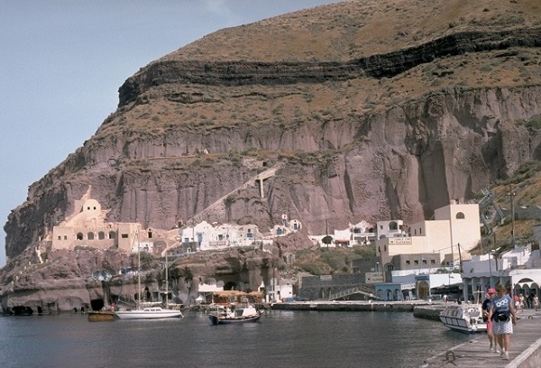
The town of Fira, seen at top in this photo, is the capital of the island of Santorini, one of two islands (plus a small islet) that protrude from the mostly submerged Thira volcanic caldera.
The opening below the church at the top left is the exit of the cable car that runs along the inner wall of the caldera to bring tourists to the old harbor below. It runs parallel to the zig-zag path that is used by hikers and mules.

The steep inner walls of Santorini, capped by whitewashed villages, drop steeply into the caldera bay.
Pyroclastic-flow deposits from four caldera-forming eruptions dating back to 100,000 years ago are exposed in the caldera walls in this north-looking view.
The youngest caldera was formed about 3500 years ago during the noted Minoan eruption of Santorini.
The flat-topped peak on the left skyline is Skaros, a remnant of a shield volcano constructed within a previous caldera.
Renowned Santorini (Thera), with its steep-walled caldera rim draped by whitewashed villages overlooking an active volcanic island in the center of a caldera bay, is one of the scenic highlights of the Aegean sea.
The circular island group is composed of overlapping shield volcanoes cut by at least four partially overlapping calderas.
The oldest southern caldera was formed about 180,000 years before present (BP), followed by the Skaros caldera about 70,000 years BP, and then the Cape Riva caldera about 21,000 years BP.
The youngest caldera formed about 3600 years BP during the Late-Bronze-Age Minoan eruption that forced abandonment of the thriving Aegean Sea island.
Post-Minoan eruptions beginning in 197 BC constructed a series of lava domes and flows that form two islands near the center of the caldera.
A submarine eruption took place in 1650 AD outside the caldera NE of Thera.
The latest eruption at Santorini produced a small lava dome and flow in 1950, accompanied by explosive activity.

This is a view of the village of Oia, located high up on the island of Santorini, as is its capital, Fira.
The island, is a narrow, crescent shaped remnant of the caldera of the Santorini volcano, left over after the catastrophic explosion of 1610 BC.
That explosion destroyed the ancient settlements on the island of Thira, and the resulting huge tsunami destroyed the Minoan civilization on the island of Crete, 150 kilometers away.
In the distance, the island of Thirasia can bee seen in the background of this photo. Thirasia is another remnant of the volcanic caldera.

The crater in the foreground was formed during an eruption from 1570-1573 AD.
The eruption was the first in more than 800 years from Santorini.
Initially submarine eruptions were followed by the formation of the new island of Mikri Kammeni (Little Burnt Island) NE of Palaea Kammeni island.
The 1570-73 eruption created a small dome-shaped island with a diameter of about 400 m and a height of 70 m, topped by a 20-m-deep crater.
The western wall of Santorini's caldera appears in the background, capped by the houses of the village of Imerovigli.

This NASA space shot from 2000 shows clearly the portions of the mostly submerged caldera that are above water.
The island of Santorini is on the right and Thirasia island at left.
The cone at the center of the caldera is Nea Kammeni, known to tourists at "the volcano", with Palaia Kammeni at its left.
The small islet between the SW edge of Sanatorini and the Southern end of Thirasia is Aspronisi, a part of the caldera wall, which extends beneath the sea surface to the Akrotiri Peninsula of Santorini.

This spectacular outcrop shows light-colored deposits from the 3500-year-old Minoan eruption of Santorini volcano filling a valley cut in darker, bedded ashfall layers of Pleistocene age.
The lower, beige-colored unit filling the ancient valley is a pumice-fall deposit from vertical explosions early in the eruption.
It is overlain by laminated pyroclastic-surge deposits produced when water gained access to the magma reservoir as the volcano collapsed into the sea.
The upper whitish layer truncating both these deposits is a pyroclastic-flow deposit.

The black lava flows that descend into Santorini's caldera bay are the Dafni lavas, erupted during 1925-26.
During this eruption, which began in August 1925 and lasted until January 1926, Nea Kameni became a single island as the Dafni lavas united Mikra Kameni, Nea Kameni and Georgios domes.
Eruptions resumed in May 1926, when small pyroclastic flows occurred.
The steep-sided eastern caldera wall rises in the distance, capped by the town of Fira and the smooth-textured pyroclastic-flow deposits of the Minoan eruption.

Santorini and the Kameni islands in a 2008 NASA photo.

The lava flow forming the peninsula (center) dates back to an eruption during 1707-1711.
Nea Kameni Island was formed between Palaea and Mikri Kameni islands during alternating explosive and effusive activity that began with uplift of a small islet of pumice called Aspronisi (White Island).
Following the eruption the new island became dotted with small churches and buildings used by residents of Santorini who came to swim in the thermal springs.
The caldera-rim islands of Thirasia (left) and Thira (right) can be seen in the distance to the NW.

Palaea Kameni Island (right-center) rises from Santorini's caldera bay SE of the foreground cliffs of Thirasia Island.
The higher, flat-topped part of the island was formed during 46-47 AD, and the gentler slopes in front of it date back to 726 AD.
The highly explosive eruption of the summer of 726 AD produced great quantities of pumice and ash that were transported as far as the islands of Abydos and Lesbos, Asia Minor, and Macedonia.
Extrusion of the Agios Nikolaos lavas followed, which eventually joined the NE tip of Thia (Palaea Kameni) Island.

Fira, the capital of the island of Santorini is shown here with the island of Thirasia in the background. Like Santorini, Thirasia sits at the top of the mostly submerged Santorini (Thira) volcano

The gentle outer flanks of the Santorini caldera, mantled by deposits of the 3500-year-old Minoan eruption, provide a setting for croplands and island villages.
This view, looking NW from Mt. Profitis Ilias, a limestone peak forming the high point of the island of Thera, shows the northern half of the 7.5 x 11 km caldera.
Its northern rim drops below sea level, leaving a channel between the tip of Thera and the island of Therasia at the left.

The steep eastern caldera walls of Santorini are draped by the whitewashed houses of the town of Fira, many of which were excavated within deposits of the late Bronze Age Minoan eruption that took place about 3500 years ago.
The most prominent unit in the caldera wall at this location is the Middle Tuff Sequence, the lighter-colored, cliff-forming unit halfway up the wall that is composed of a basal pumice-fall deposit overlain by lag-breccia and pyroclastic-flow deposits.
The Middle Tuff and the darker bedded layers overlying it were deposited during late-Pleistocene eruptions of Santorini.
The course of the late Bronze Age Minoan eruption of Santorini is charted by this roughly 10-m-thick exposure of deposits produced by the 3500-year-old eruption.
The loosely compacted basal pinkish layer (excavated here by a circular storage tunnel) is formed of early airfall pumice deposited from powerful vertical eruption columns.
It is overlain by lighter-colored, laminated deposits of pyroclastic surges produced when water gained access to the eruption column as caldera collapse began.
The thicker, upper unit consists of pyroclastic-flow deposits.

During Medieval times the Skaros promontory, formed of lavas of the Skaros shield volcano, was a densely populated Catholic fortress bristling with buildings.
The fortress was constructed because it offered protection from pirates, but following a series of strong earthquakes accompanying the 1707-1711 and other eruptions, it was progressively abandoned, and few building remnants remain.
Therasia Island lies across the caldera at the upper right, and the tip of Nea Kameni Island in the center of the caldera appears at the left.

This image shows Sanotini's spectacular "red beach", with its uniquely reddish-color sand, popular with tourists and accessible only by boat or hicking. There are also more accessible "black" beaches on the island.
Wave erosion has exposed a cross section through bedded scoria layers of the Cape Mavrorachidi cinder cone on the SW side of Thera Island.
Behind the cone to the left are exposures of light-colored rhyodacitic tuffs of the Early Centres of the Akrotiri Peninsula.
A Potassium-Argon date of 522,00 +/- 104,000 yrs Before Present (BP) and a more accurate 451,000 +/- 27,000 BP Argon-Argon date were obtained from a lava flow from the Cape Mavrorachidi cone.
The cinder cone is one of several cinder and spatter cones formed on the Akrotiri Peninsula.

A tourist boat leaves what is popularly known as "the volcano", the composit dome of Nea Kameni island, a popular tourist destination.
The blocky dacitic lava flow at the right is part of the Dafni lavas, erupted early in the course of an eruption that lasted from 1925 to 1926.
The east wall of Santorini caldera, capped by the town of Fira, rises across the caldera bay.
The 1925-1926 eruption, like many other of Santorini's post-caldera eruptions, began with submarine explosions and lava effusion.
Explosive activity was unusually strong during this eruption, producing eruption columns up to 3.2 km high.

The dark-colored lava flow at the right center of the photo and the crater in the foreground were formed during an eruption from 1939 to 1941.
The 1939-41 lava flows traveled to the east and west, reaching almost to the sea on the east side and extending into the caldera bay at several location on the west side on Nea Kameni island.
A chain of N-S-trending craters was formed during the eruption.
The crater seen in this photo cut lava flows of an earlier 1866-1870 eruption.
The town of Fira caps the rim of Santorini caldera along the horizon.

Palaea Kameni (Thia) Island in the center of the photo was formed by the extrusion of lava flows during a 46-47 AD eruption.
This was the second documented eruption producing a new island in the caldera bay.
The black lava flows in the foreground on Nea Kameni island were emplaced during an 1866-1870 eruption.
The small island in the right distance to the SW, capped by light-colored rocks of the 3600-year-old Minoan eruption, is part of the caldera wall, which extends beneath the sea surface to the Akrotiri Peninsula on the extreme left.

An aerial view from the east overlooks the outer flanks of Santorini's 7.5 x 11 km caldera.
The far caldera rim, part of which is flooded by the sea, appears at the upper left and right.
The towns of Fira and Merovigli cap the caldera rim, and farms drape the outer flanks of the volcano, which are underlain by deposits from the cataclysmic Minoan-age eruption about 3500 years ago.
The post-caldera islands of Nea and Palaea Kameni (upper-center) were constructed in the middle of the caldera during eruptions dating back to 197 BC.
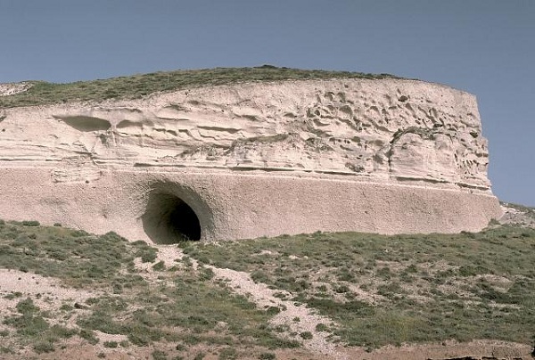
The headland of Cape Thera rises above Phira harbor.
The massive light-brown, cliff-forming unit above the harbor is the Cape Thera Ignimbrite.
Above the cliffs is a sequence of sloping minor pyroclastics and paleosols, which underlies the prominent thinner dark-colored layer at the top of the photo.
This is the Middle Pumice unit, a welded plinian pumice-fall deposit erupted about 100,000 years ago and thought to originate from a vent west of Phira.
The lower-angle slopes above it are lithic breccias of the Middle Pumice eruption.
PHOTO SOURCES: Lee Siebert 1994, Smithsonian Institution, courtesy of the Global Volcanism Program, Smithsonian National Museum of Natural History, used with permission, Vincent Bourrut photography, used with permission, NASA, Yoo Chung (Wikimedia Commons).
NOTE: The information regarding Volcano on this page is re-published from other sources. No claims are made regarding the accuracy of Volcano information contained here. All suggestions for corrections of any errors about Volcano photos should be addressed to the copyright owner noted below the photo.